In order to help eliminate or greatly minimize the practice of gerrymandering, we wish to delegate the drawing of districts to more politically balanced, neutral or fairer entities. Independent commissions are touted as a more balanced alternative to state legislators directly drawing districts. Any such entities should be staffed with statisticians, surveyors and data analysts with some oversight. Their job will be to construct districts with equal populations (as nearly as possible) that contain associative community groups in such a way as to derive a higher number of competitive districts.
Some parts of a state, county, etc. will be more populated with a certain political tendency and their districts will just have to naturally reflect that. Other parts may be more mixed and a district structure arranged there should allow for more competitive races. The final districts settled upon should be chosen from an adequate number of proposed district plans submitted by the commission or whatever delegated entity.
Concerning district boundaries we understand that straight or smooth-curve lines as seen on a map at high altitude or satellite level can actually be a rougher cut at ground level -- generally meandering about the satellite line when zoomed in upon and perhaps weaving within neighborhoods and between houses. For the inner or core districts, we strive for them to be convex (or mostly so) which means that all points within such districts can connect to all other points within their district where such lines drawn between those points are inside the shape of the district as well. Again we are talking about when looking at the boundaries from high above where they appear more smoothly as opposed to the meanderings at ground. The district shapes for the core area would be rhombi, trapezoidal, polygonal, parallelograms, triangular.
Guidelines:
As many core districts as possible should be convex or only lightly non-convex when viewed from higher above. Greater exceptions are reserved to districts along the irregular boundaries of a state, county, etc. or those edging panhandles and the like. As well, exceptions are made to districts edging natural or man-made obstacles especially when those obstacles may limit interaction of groups of communities. Some obstacles may be deserts, nature preserves, swamps, bodies of water, major highways and mountain ranges. A placing of districts that will better represent a particular minority culture, creed or ethnicity can be allowed but should not go to absurd lengths or become the basis of district delineations.
Following these guidelines along with impartial placements should eliminate or at least greatly reduce the occurrence of unusually long, thin, wormy-snaky districts or those of land-locked, intricate, jigsaw-puzzle shape being way too pinched in order to force partisan electoral gain. Districts drawn under these guidelines as viewed at high altitude or satellite level will appear to integrate more smoothly throughout the core or backbone of whatever political entity. The shapes of districts should have length-width proportions about 3-to-1 max either way.
Example:
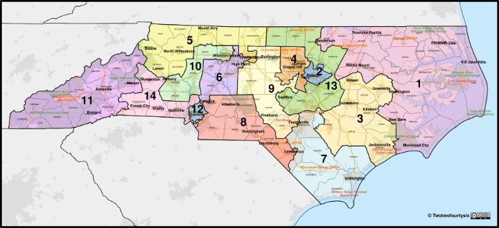
Here are the fourteen congressional districts approved for North Carolina towards the 2026 midterms.
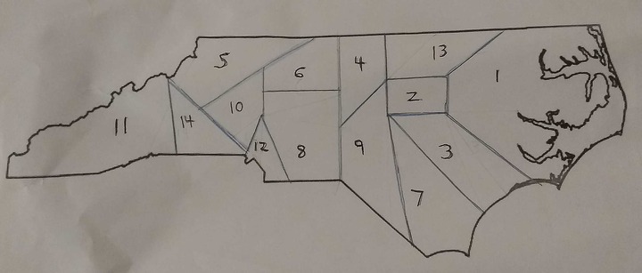
Applying the anti-gerrymandering guidelines from earlier above, what follows is a basic sketch of some possible reformed districts. The numbers of the districts below correspond to the district numbers in the previous graphic according to derivation from their original district. The sketch may not necessarily be how the new districts would get placed but it serves as an example of how the guidelines can affect the shapes and boundaries of the original fourteen.
By the way, it wasn't always the case that congressional districts were meted out with such consideration as to equal populations and there was reason as to why. Also we note that the Constitution itself does not demand that each representative has to be elected by a district. It options that issue to the states or Congress. So another possible way to avoid gerrymandering completely is to nix districts and have representatives chosen by other methods like at-large proportional representation.